Key Rings, Novelty Flags, Point Shot, Boston Celtics, Bebidas, Chartbooks
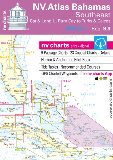
NV Charts 9.3 Bahamas Southeast 2022/23
$ 91.49
NV Charts • Reg.9.3: Bahamas Southeast • Cat & Long Island – Rum Cay to Turk & Caicos Format: Kombipack Paper / Digital download and App 8 Overview charts 21 Coastal charts & Details Includes Harbor & Anchorage Pilot Book GPS Charted Waypoints – Approaches Tide Tables – Recommended Course Pilot book The NV Charts are characterized by fine contours and easy to distinguish color graduations of the depth lines – turquoise for coral reefs, red for the 2-meter-line and blue for the 5-m-areas. Presented in a handy, user friendly size, (23½’’ x 16 ½’’, 11.7 x 16.5 folded) a thick plastic envelope protects the charts, enabling them to be easily stored. The importance of good graphical representation of the topography when sailing in the Caribbean is essential. Well marked rivers, towns and street plans all help to give a clear overall view of the shoreside facilities of the islands. Red numbered waypoints with coordinates based on WGS 84 enable yachtsmen to navigate using their GPS instruments. Heights and depths are given in the internationally accepted format of meters. Large scale approaches and land contour markings simplify the entrance into anchorages. Overview charts C0 Caribbean Sea 1:6,500.000 C1 Bahamas South 1: 900.000 C2 Exuma Sound · South 1: 340.000 C3 Ragged I. · Long I.to South Rock 1: 340.000 C4 Rum Cay to Acklins Island 1: 340.000 C5 Acklins Island to Turks & Caicos 1: 340.000 C6 Great Inagua to Turks & Caicos 1: 340.000 C7 Crooked Island to Providenciales 1: 340.000 C8 Turks & Caicos Islands 1: 340.000 Coastal Charts C9 Cat Island · North 1: 90,000 C10 Cat Island · South 1: 90,000 C11 Long Island · North 1: 90,000 C12 Long Island · Middle 1: 90,000 C13 Long Island · South 1: 90,000 C14 Ragged Islands · North 1: 90,000 C15 Ragged Islands · Middle 1: 90,000 C16 Ragged Islands · South 1: 90,000 C17 Rum Cay 1: 90,000 C18 San Salvador 1: 90,000 C19 Crooked Island · Northwest 1: 90,000 C20 Acklins Island · North 1: 90,000 C21 Acklins Island · South 1: 90,000 C22 Conception Island 1: 40,000 C23A Hogsty Reef 1: 40,000 C23B Abrahams Bay 1: 40,000 C23C Mira Por Vos Cays 1: 40,000 C24 Samana Cay to Acklins & Plana Cays 1: 180,000 C25 Plana Cays to Mayaguana I. 1: 180,000 C26 Great Inagua Island · West 1: 90.000 C27 Caicos Islands · West 1: 90,000 C28 Caicos Islands · Southeast 1: 90,000 C29 Turks Islands 1: 90,000 Legend · General Notes p.31 Tide Tables p.32 Harbor & Anchorage Pilot Book attached Dimensions: 17 in × 12 in × 0.75 in
Related products
-
-
 Notions Pack tarros de mermeladas - 6x340 ml $ 31.83 Select options This product has multiple variants. The options may be chosen on the product page
 -
-